148 PNG Heightmaps from USA (27 states) with 8129 x 8129 resolution and 6 example maps.
IMPORTANT: The FREE plugin Export to PNG has not been updated yet to UE5, so you will not be able to export the heightmaps from UE5 with it. So for the moment, if you want to use the plugin Export PNG, you need to use any of the versions 4.21 – 4.27 to export the heightmaps and once exported, you can reimport them in any UE5 projects and everything works as it should. If you don’t want to use the plugin Export to PNG, you can use the FREE plugin ILIAD, which works without any problem on UE5 and can also be found on Unreal Marketplace.
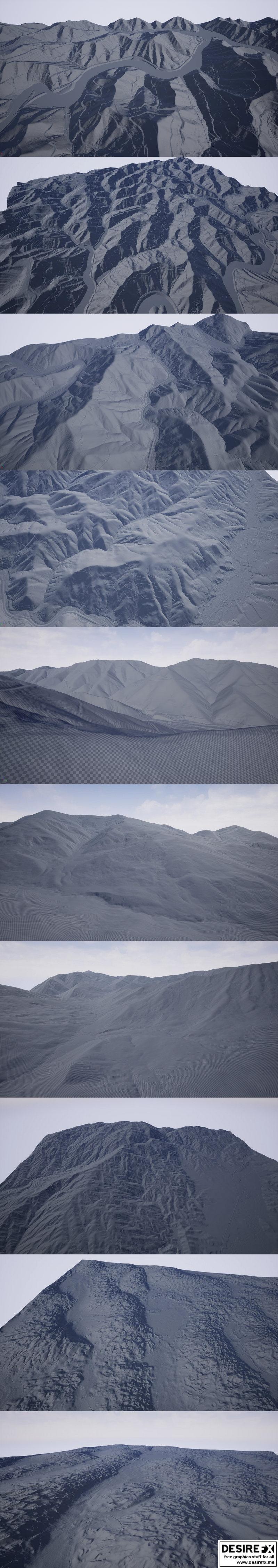
This pack contains 148 real-world PNG greyscale heightmaps which will help you digitally recreate in Unreal Engine, breathtaking landscapes from USA. I tried to offer as much diversity as possible so in this pack there are landscapes from 27 states: Arizona, California, Colorado, Georgia, Idaho, Illinois, Indiana, Iowa, Kansas, Kentucky, Los Angeles, Mississippi, Montana, Nebraska, New Hampshire, New Mexico, New York, Ohio, Oklahoma, Oregon, Tennessee, Texas, Utah, Virginia, Washington, Wisconsin, Wyoming. All heightmaps have a resolution of 8129 x 8129 (recommended by Unreal) and each landscape will have a surface area of about 64 square Km. To recreate these landscapes I used Digital Elevation Models with 1 meters precision so they are extremely accurate . The heightmaps (landscapes) are perfect for photorealistic scenes in games, movies or any other realistic open – world project.
Original_Link_https://unrealengine.com/marketplace/en-US/product/8k-usa-heightmaps